Bylaw 17062
July 9, 2015
1. The Development Officer shall calculate building Height by determining the roof type, and applying the following:
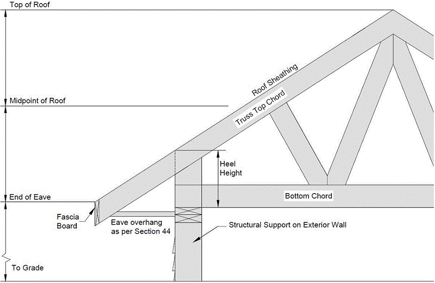
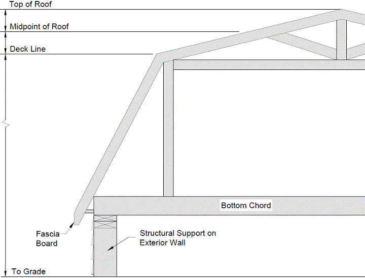
For hip and gable roof types Height shall be determined by measuring from the horizontal plane through Grade to the midpoint of the highest roof. The midpoint is determined to be between the end of the eave (intersection of the fascia board and the top of the roof sheathing, or less, in accordance with Section 44), and the top of the roof; or
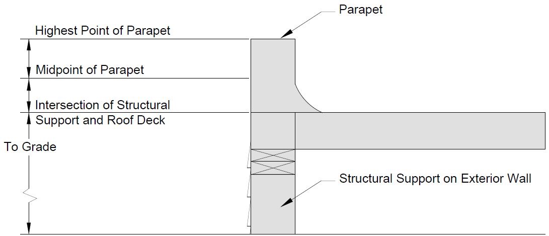
For the flat roof type, Height shall be determined by measuring from the horizontal plane through Grade to the midpoint of the highest parapet, provided the resulting top of the parapet is no more than 0.4 metres above the maximum Height allowed in the zone or overlay; or
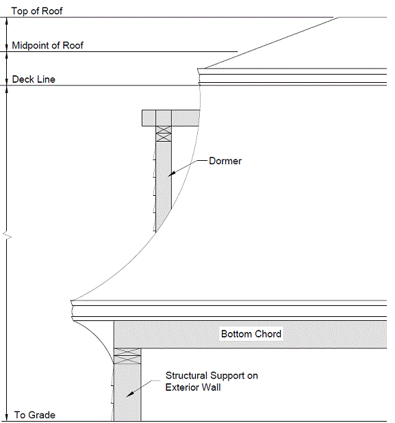
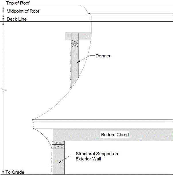
For mansard and gambrel roof types, Height shall be determined by measuring from the horizontal plane through Grade to the midpoint of the highest roof. The midpoint is determined to be between the deck line and the top of the roof; or
For all other roof types, including saddle, dome, dual-pitch, shed, butterfly or combination roofs, the Development Officer shall determine Height by applying one of the previous three types that is most appropriate for balancing the development rights and the land use impact on adjacent properties.
In determining whether a development conforms to the maximum Height permissible in any Zone, the following regulations shall apply:
Bylaw 17934
April 10, 2017
Charter Bylaw 19502
February 9, 2021
in any Zone other than a Residential Zone, the following features shall not be considered for the purpose of Height determination: chimney stacks, either free-standing or roof mounted, steeples, belfries, domes, or spires, monuments, elevator housings, roof stairways, entrances, water or other tanks, ventilating equipment, skylights, fire walls, plumbing stacks, receiving or transmitting structures, masts, flag poles, clearance markers, Solar Collectors, or other similar erections.
in any Residential Zone, those features specified in subsection 52.2(a) shall not be considered for the purpose of Height determination, except that the maximum Height of receiving or transmitting structures, where these are Satellite Signal Receiving Antennae or Amateur Radio Antennae and Support Structures, shall be calculated in accordance with the regulations of subsections 50.5 and 50.6, respectively, of this Bylaw. The maximum Height for all other receiving or transmitting structures, other than those which may normally be required for adequate local television reception, shall be the maximum Height in the Zone, and not the maximum Height for Accessory buildings in Residential Zones specified in subsection 50.3(2);
Bylaw 18115
July 10, 2017
Effective Date: September 1, 2017
Charter Bylaw 19502
February 9, 2021
Where the maximum Height as determined by Section 52.1 is measured to the midpoint, the ridge line of the roof shall not extend more than 1.7 m above the maximum permitted building Height of the Zone or overlay, or in the case of a Garden Suite the maximum permitted building Height in accordance with Section 87 of this Bylaw.
An applicant shall submit, for any Development Permit to construct, rebuild or increase the Height of a structure, a grading plan that shows the elevation of the Site at each corner of the Site before and after construction;
Bylaw 18115
July 10, 2017
Effective Date: September 1, 2017
The Development Officer shall determine Grade by selecting, from the methods listed below, the method that best ensures compatibility with surrounding development:
if the applicant can show by reference to reliable topographical maps that the elevation of the Site varies by no more than one meter in 30 lineal meters, the Development Officer may determine Grade by calculating the average of the highest and lowest elevation on the Site;
the Development Officer may determine Grade by calculating the average of the elevation at the corners of the Site prior to construction as shown on the applicant's grading plan;
the Development Officer may determine Grade by calculating the average elevation of the corners of the buildings on all properties Abutting the Site or separated from the Site by a Lane;
for a Site where the highest geodetic elevation at a corner of the front property line is greater than the lowest geodetic elevation at a corner of the rear property line by 2.0 m or more, the Development Officer may determine Grade by calculating the average elevation of the front corners of the Lot, and along the side property lines a distance equal to the minimum front Setback in the underlying Zone from the front property line. This method is intended for small scale development with a single Principal building and is not intended to be used for Multi-unit Project Developments;
for a Garden Suite, the Development Officer may determine Grade by calculating the average of the elevation of the corners at the Rear Lot Line prior to construction as shown on the applicant’s Site Plan; or
the Development Officer may use his variance power to determine Grade by a method other than the ones described in subsection 52.4. If so, this shall be a Class B Discretionary Development.
The applicant shall submit all information the Development Officer requires to determine Grade by the method the Development Officer chooses.
Charter Bylaw 18381
May 7, 2018
The Development Officer shall determine Height for Platform Structures and unenclosed steps, including landings, by measuring the greatest vertical distance between the top of the structure and the finished ground level below it, excluding railings and any artificial embankment.