Bylaw 14011
Amendment No. 555
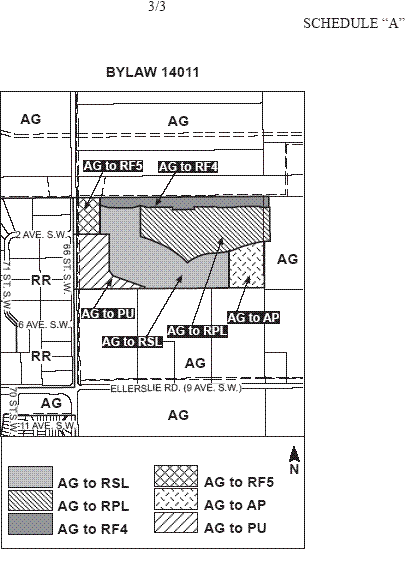
WHEREAS Block D, Plan 5347 RS and a portion of Plan 782 2211, Lot 2; located east of 66 Street SW and south of the Transportation and Utility Corridor, Rural Southeast, Edmonton, Alberta, are specified on the Zoning Map as (AG) Agricultural Zone; and
WHEREAS an application was made to rezone the above described property to (AP) Public Parks Zone, (PU) Public Utility Zone, (RSL) Residential Small Lot Zone, (RPL) Planned Lot Residential Zone, (RF4) Semi-detached Residential Zone and (RF5) Row Housing Zone;
NOW THEREFORE after due compliance with the relevant provisions of the Municipal Government Act RSA 2000, ch. M-26, as amended, the Municipal Council of the City of Edmonton duly assembled enacts as follows:
1. The Zoning Map, being Part III to Bylaw 12800 The Edmonton Zoning Bylaw is hereby amended by rezoning the lands legally described as Block D, Plan 5347 RS and a portion of Plan 782 2211, Lot 2, located east of 66 Street SW and south of the Transportation and Utility Corridor, Edmonton, Alberta, which lands are shown on the sketch plan annexed hereto as Schedule ”A”, from (AG) Agricultural Zone to (AP) Public Parks Zone, (PU) Public Utility Zone, (RSL) Residential Small Lot Zone, (RPL) Planned Lot Residential Zone, (RF4) Semi-detached Residential Zone and (RF5) Row Housing Zone.