Bylaw 16889
August 25, 2014
The purpose of this DC1 Provision is to facilitate the development of a pedestrian friendly Community Commercial Centre that may accommodate a range of commercial, residential, office, entertainment, cultural and institutional uses such that development is appropriate in appearance and function to a site bounded by two arterial roadways, a collector roadway and a future Transit Priority Corridor; and abutting a natural area, a medium density residential site, and an existing historic religious assembly. .
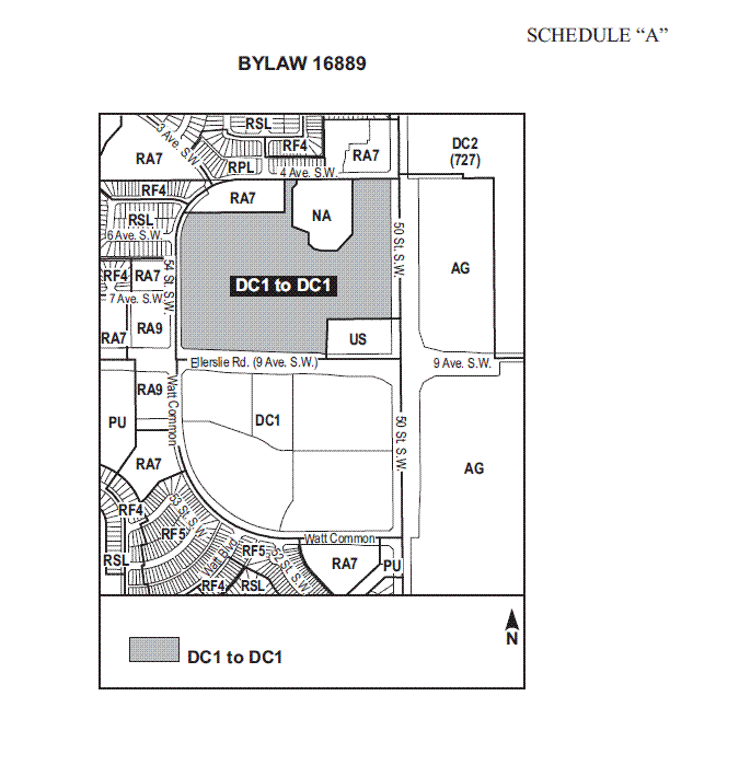
This Provision shall apply to a portion of Lot B, Block 22, Plan 1122045 containing approximately 14 ha of land, as shown on Schedule ”A” of the Bylaw, adopting this Provision .
Ensure on-site development:
becomes a focal point for the surrounding area;
functions as a walkable commercial centre with a pedestrian friendly commercial node, creating a sense of place for users;
relates appropriately to adjacent built forms, roadways, uses, functions and activities;
creates an attractive and cohesive visual identity;
includes outdoor spaces of interest;
presents an attractive streetscape along external roadways; and
is sympathetic to the presence and function of future abutting public transit facilities, existing religious assembly and natural area.
Ensure buildings are developed:
in a harmonious architectural theme;
with 360 degree architecture and such that all facades are visually attractive and interesting;
with clearly defined entrances; and
with high quality and durable building materials and finishes.
Ensure interior access roads and walkways promote contiguous and logical patterns of safe pedestrian and vehicular movement throughout the site and between the site and surrounding development and uses.
Ensure parking areas:
facilitate safe and convenient pedestrian movements
are appropriately landscaped to soften their appearance and add visual interest; and
are dispersed and segmented
Apartment Hotels
Bars and Neighbourhood Pubs
Business Support Services
Child Care Services
Commercial Schools
Convenience Retail Stores
Custom Manufacturing Establishments
Drive-in Food Service
Flea Markets, limited to farmers market involving the sale of items such as local produce and handicrafts
Gas Bars
General Retail Stores
Government Services
Health Services
Hotels
Indoor Participant Recreation Service
Major Alcohol Sales
Major Amusement Establishments
Media Studios
Minor Amusement Establishments
Minor Home Base Business
Minor Secondhand Stores
Minor Service Stations
Nightclubs
Personal Service Shops
Private Clubs
Private Education Services
Professional, Financial and Office Support Services
bb. Public Libraries and Cultural Exhibits
cc. Rapid Drive-through Vehicle Services
dd. Religious Assembly
ee. Restaurants
ff. Specialty Food Services
gg. Spectator Entertainment Establishments
hh. Veterinary Services
ii. Warehouse Sales
jj. Fascia On-premises Signs
kk. Projecting On-premises Signs
ll. Roof On-premises Signs
mm. Temporary On-premises Signs
nn. Freestanding On-premises Signs
oo. Minor Digital On-premises Signs
pp. Major Digital Signs
Apartment Housing as shown in Appendix I
Live Work Unit
Development shall be in general accordance with the objectives and the attached appendices:
Appendix I, Concept Plan; and
Appendix II, Pedestrian Connections.
At the Development Permit stage, a generalized, non-binding, concept plan shall be submitted for all new building development or substantial redevelopment to illustrate how the proposed development will integrate with existing and future surrounding and on-site development. The concept plans shall show the location of existing and future buildings, parking areas, vehicular and pedestrian routes and Amenity Areas.
The maximum Floor Area Ratio for non-residential uses shall not exceed 0.4 based on the total Site Area.
The maximum building height shall be 20.0 m for non residential uses.
Apartment housing may be accommodated in:
free standing residential building with or without ground floor office, commercial, retail uses and may have row or stacked row housing at the base; or
part of a comprehensively developed project where buildings are attached and can vary from predominately residential to mixed use.
Apartment Housing shall be developed in accordance with Sections of Zoning Bylaw except that the maximum height shall not exceed 45 m.
Live Work Units shall comply with the following regulations:
the live work units shall be located within the residential locations;
each unit shall have individual access at grade;
the number of non-resident employees or business partners working on-site shall not exceed two at any one time;
there shall be no outdoor business activity, or outdoor storage of material or equipment associated with the Business. Indoor storage related to the business activity shall be allowed in either the Dwelling or Accessory Building;
there shall be no nuisance created by the business by way of electronic interference, dust, noise, odor, smoke, bright light or anything of an offensive or objectionable nature which is detectable to normal sensory perception outside the Live Work unit; and;
each application for a Development Permit for the Use Class Live Work shall include a description of the business to be undertaken at the premises, an indication of the estimated number of business visits per week, provision for vehicular and bicycle parking for residents, visitors and employees, and where any material or equipment associated with the business use are to be stored; and
Individual business identification signs located on the façades of Live Work units shall be designed to ensure the signage does not detract from the overall appearance of the development and that the signage is not obtrusive, having regard to the scale of the buildings on the Site.
A minimum 6.0 m landscaped Yard shall be provided abutting all public roadways (i.e. Ellerslie Road SW, 50 Street SW, 54 Street SW, and 4 Avenue SW).
A minimum Amenity Area of 1.0 m2 shall be provided for every 10 surface parking spaces. An additional Amenity Area of 1.0 m2 shall be provided for every 100 m2 of commercial floor space.
A CPTED Assessment shall be completed to guide the design of public and private spaces and facilities, focusing on natural surveillance and access control.
Signs for non-residential development shall comply with the regulations in Schedule 59 F, and be subject to the following:
a Comprehensive Sign Design Plan for the overall Site, identifying all Freestanding On Premises Signs, including Minor and Major Digital signs, shall be submitted to the satisfaction of the Development Officer, in accordance to Section 59.3 of the Zoning Bylaw, as amended; and
Development applications for signs identified within the Comprehensive Sign Design Plan may be permitted in stages. For context and the Development Officer’s interpretation purposes, the Comprehensive Sign Design site plan shall be submitted at each Development Permit application, to illustrate how the proposed signs will integrate with existing and future on-site development.
Signs for residential development shall comply with the regulations in Schedule 59 B of the Zoning Bylaw, as amended.
The owner shall enter into an Agreement (or Agreements) with the City of Edmonton for the following:
Construction of portions of the two adjacent arterial roadways (i.e. 50 Street SW and Ellerslie Road). Construction shall include channelization, accesses intersections, multi-use trails, sidewalks, lighting, landscaping and transitional improvements where applicable;
Dedication of the required road right-of-ways for the construction of 50 Street SW and Ellerslie Road as described in the Memorandum of Understanding signed December 2007. Roadway dedication shall be to the satisfaction of the Transportation Department;
Payment of the proportionate share of the Arterial Roadway Assessment for the construction of arterial roadways in the catchment area in accordance with the Arterial Roads for Development Bylaw; and
Repair of any damage to the abutting roadways, alleys, sidewalks, and/or boulevards resulting from the construction of the development, to the satisfaction of the Transportation Department. The site must be inspected by the Transportation Department prior to the start of construction and once again when construction is complete.
Buildings shall generally, to the satisfaction of the Development Officer, be oriented to:
frame (located at) the corner of the prominent intersection of two private internal roadways;
frame the pedestrian friendly commercial node as illustrated in Appendix I.
frame major vehicular/pedestrian entry/exit points to/from the site;
permit views into the site along the axis of roadways and walkways intersecting the abutting perimeter public roadways; and
permit views of the abutting natural area identified in Appendix I.
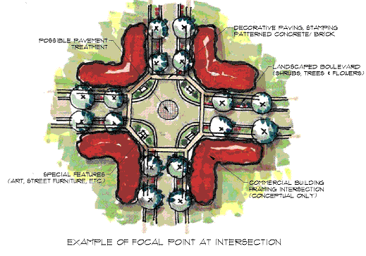
Focal points identified in Appendix I and II, shall be designed and intended to provide special features and vistas within the site and promote social interaction. The focal point may include:
An architectural feature such as a clock tower, spire or interesting roof feature; and
Public art / water features, a public plaza, open space, street furniture, or landscaped feature.
The location of the pedestrian friendly commercial node shown in Appendix I will be determined at the Development Permit stage, however it will be located at the intersection of the two main private internal roads.
The pedestrian friendly commercial node, shown in Appendix I, shall be designed in the following manner (see Figure 1):
clustering of Commercial Retail Units (CRUs) on both sides of the private internal roadway;
at least 50% of the ground floor fronting the private internal road shall be glazed to the exterior;
horizontal breaks of uninterrupted façade shall not exceed 12.0 m in length;
at least 50% of the ground floor commercial premises shall consist of individual shops of not more than 12.0 m frontage;
an amenity area within each node;
decorative paving, stamping or patterned concrete/brick to identify pedestrian crossings as shown in Figure 1.
Figure 1: Example of Pedestrian Friendly Commercial Node
Along the private internal roadways, the spaces between freestanding structures shall be improved to include landscaped pedestrian connections and:
Small pockets of landscaped parking areas;
Public seating areas; and
Landscaped open spaces.
Not including the entrances and access points, a maximum of 40% of the frontages abutting the landscaped Yard along Ellerslie Road and 50 Street SW may be developed with surface parking.
Surface parking abutting 4 Avenue SW and 54 Street SW shall be screened from view using berms, and/or landscaping or similar screening features.
Service lanes and/or loading areas shall not be permitted to abut the south side of the adjacent multi-family residential site.
Buildings shall use a variety of architectural elements and treatments, materials and colours, to break up the massing and provide human scale development.
The massing of building walls greater than 15.0 m in length shall be reduced through the use of architectural elements such as columns, ribs, pilasters or piers, changes in plane (e.g., recesses and projections), changes in building finishes, materials and textures, or other features that create an identifiable pattern and sense of human scale (see Figure 1.0 - Example of Building Elevation). Landscaping along large format buildings shall be arranged in a manner that reduces and softens the building edge and creates visual relief.
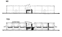
Figure 2.0 - Example of Building Elevation
No walls that face a public street, private internal roadways or connecting pedestrian walkway shall have a blank uninterrupted length exceeding 15.0 m.
The façade of a building facing a public plaza, focal point or public Amenity Area shall be designed and finished to create an active streetscape, visual interest, and human scale by use of architectural features such as false entryways or entryways, windows, arcades, arbors, awnings, and trellises.
Buildings shall be finished with durable materials of a quality that will retain their appearance over time, including, but not limited to, natural and synthetic stone, brick, acrylic stucco, metal and glazing.
Colour schemes shall tie building elements together, relate buildings to one another, and enhance the architectural form of a building.
All Buildings, including those whose tenants typically employ ”chain architecture”, shall be designed and finished to generally conform to a consistent architectural theme using similar architectural design elements, materials and colours. ”Chain architecture” shall generally be limited to corporate logos and signage.
All buildings shall be developed with 360 degree architecture such that all facades are visually attractive and interesting.
Buildings shall be designed to include a clearly identifiable primary entrance through the use of recesses, projections, canopies, porticos, overhangs, arcades, peaked roof forms, arches, outdoor patios, display windows, planters, walls, or other similar design elements (See Figure 3).
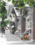
Figure 3.0 - Example of Commercial Retail Unit Frontage
Building rooftop mechanical equipment shall be concealed from the public in a manner that is consistent with the character of the building.
Private internal roadways shall be established to accommodate the peak traffic volumes for the site to the satisfaction of the Transportation Department.
Pedestrian connections as shown in Appendix II connecting the shopping and Amenity Areas shall be established through the utilization of clearly demarcated walkways, lighting and signage systems to reduce pedestrian conflict and create a more pedestrian friendly image.
The private internal roads as shown on Appendix I where deemed appropriate shall serve as collector streets and shall be developed, in addition to walkways, to the satisfaction of the Development Officer in consultation with the Transportation Department, to encourage pedestrian movement and / or provide access to:
abutting buildings
parking areas and / or parking structures
site amenities and focal points
sidewalks along public roadways
transit stops
defined crossing locations at all arterial and collector intersections
Pedestrian connections shall consist of the following types as shown on Appendix II:
Enhanced multi-use trail
Multi-use trail
Enhanced parking island with walkway (Figure 4.0)
Pedestrian sidewalk
Building front sidewalks
Pedestrian connections shall be developed generally as shown on Appendix II in the following ways:
Enhanced multi-use trail - A 12.0 m landscaped yard shall be developed as an enhanced pedestrian corridor as a means of creating an improved interface between the adjacent multi-family residential site and the commercial site. This yard shall include landscaping, pedestrian level lighting, and a 3.0 m hard surfaced multi-use trail with a dividing yellow centerline and ’Shared Use’ signage;
Multi-use trails shall include landscaping, pedestrian level lighting, and a 3.0 m hard surfaced multi-use trail with a dividing yellow centerline and ’Shared Use’ signage;
Enhanced parking island with walkway shall include landscaped islands with raised curbs and a 1.5 m sidewalk. Remedial treatment such as raised pedestrian crossings, landscaping, forecourts and landings, special paving, light and bollards shall be provided at significant points of pedestrian and vehicular crossings;
Pedestrian sidewalks shall be a minimum 1.5 m wide and developed along the private internal roadways with boulevard landscaping; and
Building sidewalks shall be provided in the front of large format buildings at a minimum of 3.0 m in width, the fronts of free standing buildings at a minimum of 2.0 m in width and the fronts of the buildings of the Pedestrian Commercial Shopping Node at a minimum of 3.0 m.
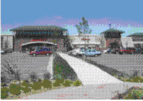
Figure 4.0 - Example of enhanced parking island with walkway
The owner shall fund traffic signals at the following potential locations, as shown on Appendix I, if and when warranted by the development:
the intersection of 50 Street SW and 4 Avenue SW (included in the Arterial Roads for Development Bylaw and shall be funded in accordance with the bylaw);
the intersection of 54 Street SW and Ellerslie Road (included in the Arterial Roads for Development Bylaw and shall be funded in accordance with the bylaw);
the all-directional access to 4 Avenue SW;
the all-direction access to 54 Street SW; and
the all-directional access to Ellerslie Road.
Allow vehicular and pedestrian cross lot access and circulation to all areas within the commercial precinct to facilitate direct access to shopping.
Vehicular and bicycle parking shall be provided in accordance with Section 54 of the Zoning Bylaw, as amended, and located to the satisfaction of the Development Officer and Transportation Services.
Large parking areas shall be ”broken up” by means of on site private roads, drive aisles, pedestrian corridors and / or landscaped islands.
Garbage collection for all buildings shall be located within a structure or enclosure that is architecturally compatible with the project design and screened from view of any residential site. Gates and/or doors of the garbage enclosures must not open or encroach into public or private road right-of-way.
Loading and service areas shall be screened from abutting public roadways and uses and designed to ensure vehicles do not encroach or back onto public road right-of-way or the private internal roadways.
A detailed landscaping plan shall be submitted in accordance with Section 55 of the Zoning Bylaw, as amended, prior to the approval of any development permit. This plan shall illustrate landscaping internal to the site, Amenity Areas and pedestrian linkages. Outdoor amenity spaces shall be landscaped for the purpose of achieving pedestrian connectivity, opportunities for play and social interaction. Furthermore, outdoor amenity spaces shall create a sense of place, character and identity. In addition to landscaping, this shall be achieved through the use of park benches, pedestrian level lighting, waste receptacles and other means integrated with the landscaping and placed along public walking routes through the site to the satisfaction of the Development Officer.
Notwithstanding Section 55 of the Zoning Bylaw, landscaping requirements shall exceed the minimum requirements for the number of trees and shrubs required by 10%.
Landscaped Yards shall not be used in the calculation of Amenity Areas.
Landscaped areas shall utilize the three tiered planting system: 1) grasses and ground covers; 2) shrubs; 3) trees. All areas not covered with structures, yards, walkways, roadways, driveways, and parking spaces shall be landscaped. Low maintenance landscaping or naturalized vegetation types are encouraged.
All parking areas fronting on to the arterial roadways shall be screened from view primarily by vertical landscaping inclusive of earth berms and trees and shrubs.
Landscaping at site entrances shall include:
the use of ornamental plant material, shrubs, and planting beds
planting shall be massed and sized as appropriate for the entryway size and space
surface treatments to further enhance the appearance of the entrance
Coordinated and complementary streetscape enhancements shall be developed through the site, including street trees, fencing, pedestrian scaled lighting, street furniture and other elements.
Where fences are developed they shall be consistent in design, materials, finishes, and colours with the dominant architectural theme for the site.
The required Amenity Areas may be provided in the form of focal points, courtyards, interior landscaped open spaces, arcades, plazas, parkettes, commons, squares, greens, gathering places and public seating areas. The Amenity Areas may be developed with landscaping, planting beds, public art, street furniture and water features to facilitate social interaction amongst site users and create a ”sense of place”. Amenity Areas shall be distributed to be readily accessible to both visitors and on-site employees.
Landscaping shall be used to highlight major circulation patterns, on-site walkways, pedestrian corridors, multi-use trails and the overall development.
The focal point on the south side of the natural area shall be open and accessible by a pedestrian corridor or a private internal roadway for a length of 30.0 m.
Any residential building sited adjacent to the natural area shall be oriented to ensure that residents have direct views of the natural area and active residential frontages. Active residential frontages shall include ground level units with individual unit external accesses and use features such as porches, staircases and stoops.
Adjacent to the southern portion of the natural area, a 7.5 m building setback shall be provided, as shown on Appendix II.
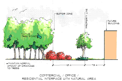
Figure 5
A minimum 15.0 m building setback shall be provided abutting Lot 5, Plan 8221657 (historical religious assembly).
Within the building setback, a 5.0 m landscaped Yard shall be provided on the north and west side of the religious assembly site (See Figure 6).
A 1.5 m sidewalk shall be provided within the landscaped yard along a portion of the north boundary of the religious assembly as shown on Appendix II.
An appropriate interface / integration shall be created between the Site and the existing religious assembly by incorporating similar or sympathetic architectural features (i.e. material, colours) on buildings in proximity to the Site. The interface with the west side of the existing historical religious assembly site will incorporate protection of the viewshed corridor of the historical structure.
The owner shall register a public access easement, as shown on Appendix I, on all Certificates of Title for the commercial Site to ensure vehicular and pedestrian access from Ellerslie Road and 50 Street through the commercial site to Lot 5, Plan 822 1657 (historic religious assembly) as shown on Appendix I.
Major Alcohol Sales, Nightclubs, Bars and Neighbourhood pubs, and Drive-in Food Service shall not be permitted within 15.0 m of Lot 5, Plan 8221657 (historical religious assembly).
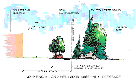
Figure 6